The Buller Coast: Wild, Untamed, and Impossible to Ignore
Coastal in Buller
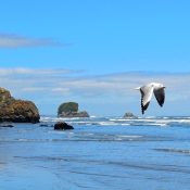
The coastline in Buller has a presence you feel straight away. It’s open, exposed, and constantly shifting. The Tasman Sea meets the land without much interruption, shaping everything from the rock formations to the way the light moves across the water.
Spending time along the coast isn’t about finding one perfect viewpoint. It’s about moving through it. Walking sections of beach, stopping at lookouts, and noticing how quickly conditions change. Some days it feels expansive and calm. Other days it carries more weight, with wind, swell, and sea spray shaping the experience.
What You’ll Find in Buller
The coastal stretch through Buller runs from south of Punakaiki, through Westport, and continues north toward Karamea. Along the way, the landscape shifts between limestone formations, long beaches, rocky headlands, and sections where forest meets the sea.
Near Punakaiki, the coastline is defined by its geological features. Limestone formations rise out of the ground and extend toward the ocean, creating natural platforms, blowholes, and layered rock structures. Around Westport, the coast opens up into longer, more accessible beaches where the scale of the landscape becomes more apparent. Further north, toward Karamea, the coastline begins to feel more remote, with fewer access points and a stronger sense of distance.
Each section offers something slightly different, but they are all shaped by the same forces of sea and weather.
- Pancake Rocks and blowholes (Punakaiki)
- Truman Track coastline views
- Cape Foulwind and seal colony
- Tauranga Bay beach
- North Beach (near Westport)
- Charleston coastline
- Remote beaches north toward Karamea
Limestone Coast and Formations
One of the most distinctive parts of the Buller coastline sits around Punakaiki. The Pancake Rocks and blowholes are a well-known feature, where layered limestone has been shaped over time into formations that look almost stacked.
At certain times, particularly with higher swell, the blowholes become active, sending water upward through the rock. Even when conditions are calmer, the formations themselves are worth seeing, especially when viewed from the surrounding tracks.
Beyond the main viewing areas, the coastline continues with smaller formations and sections of bush that lead down toward the sea. These areas often feel less structured and allow for a more open experience of the coastline.
Beaches and Open Coastline
Around Westport, the coastline opens into long stretches of beach. These areas are shaped by tide, wind, and driftwood, and they tend to feel expansive rather than enclosed.
Walking along these beaches is one of the simplest ways to experience the coast. The space allows you to move at your own pace, whether that’s a short wander or a longer walk. The ocean is rarely still, and the constant movement adds to the sense of being in a place that isn’t fixed.
Some sections are popular with locals, while others remain quieter, especially if you move slightly away from main access points.
Remote Coastal Sections
Heading north toward Karamea, the coastline becomes less developed. Access points are fewer, and the surrounding landscape feels more untouched.
In these areas, the coast can feel more isolated, particularly outside peak travel periods. Beaches may stretch without interruption, and the connection between forest and sea becomes more direct.
Reaching these places often involves a bit more time and planning, but they offer a different experience from the more accessible sections further south.
Coastal Walks and Lookouts
Throughout Buller, there are multiple points where tracks lead to coastal viewpoints or follow sections of the shoreline. Around Punakaiki, well-formed tracks guide visitors through bush and along the coast, while near Westport, shorter walks and access points connect easily to the beach.
These tracks provide a way to see the coastline from different perspectives. From above, the scale becomes more apparent. At sea level, the texture and detail of the landscape come through more clearly.
Who This Is For
The Buller coastline suits a wide range of visitors. It works for those wanting an easy, accessible experience, as well as those willing to travel further for more remote sections.
It’s well suited to:
- Travellers wanting to break up a journey with scenic stops
- Visitors who enjoy walking and exploring at their own pace
- Those comfortable with open, exposed environments
You don’t need specialised skills to experience the coast, but an awareness of conditions will make a difference.
Local Insight
The coastline is heavily influenced by weather and tide. What you see and experience can change within a short period of time.
Tide levels affect beach access, swell influences how active features like blowholes are, and wind can shift how exposed an area feels. Rather than aiming for one specific condition, it’s often better to experience the coast as it is on the day.
Moving between different coastal spots can also change the experience quickly, even within a short distance.
Practical Information
Access to the coastline is generally straightforward, with many entry points located just off the main road. Parking areas and short tracks make it easy to reach key locations.
Local information centres can provide up-to-date advice on coastal conditions, including tide information and access. In places like Westport, Punakaiki, and Karamea, they are a useful place to check in, particularly if you are planning your day around the coast.
Facilities are available in the main towns, but more remote coastal areas may have limited services. Being prepared for changing weather and bringing an extra layer is recommended.
Nearby Connections
The coastline connects naturally with other parts of Buller. Many coastal stops lead into walking tracks, while nearby rivers meet the sea and create different environments again.
Around Punakaiki, coastal exploration links closely with forest and limestone landscapes. Near Westport, it connects easily with river access and inland routes. Further north, toward Karamea, the coast becomes part of a more remote journey through the region.
Wherever you enter it, the coastline tends to draw you along, leading from one section to the next without needing much direction.